Kathmandu to Nagarkot
Buses, taxis, private cars, and ride apps — compare options for the trip up to the ridge, with realistic timing and app tips for Pathao, inDrive, and Yango.
~32 km
from central Kathmandu
1.5–3 hrs
typical by road
~2,175 m
Nagarkot ridge
Winding climb
after Bhaktapur
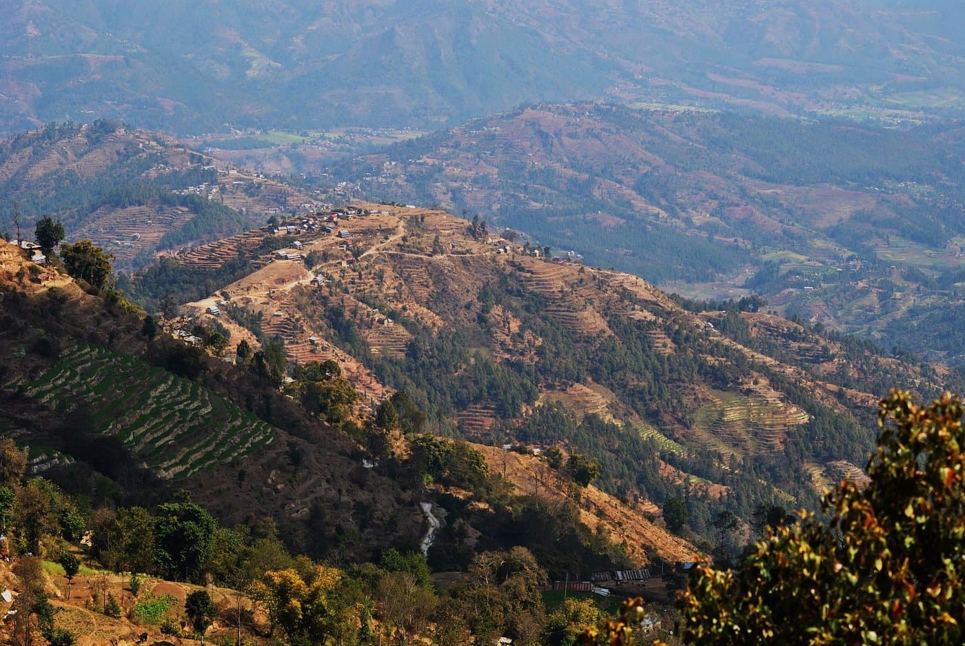
Nagarkot sits on a forested ridge east of Kathmandu — about 32 km by road, usually 1.5 to 3 hours depending on traffic and where you start. The climb after Bhaktapur is winding; buses stop often, while taxis and apps get you door-to-door. Use the sections below to compare buses, private cars, and Pathao, inDrive, and Yango before you travel.
Choose your mode
How travellers reach Nagarkot
Same winding road for everyone — below, the main ways people make the trip, from ride-hailing cars to buses and bikes.
Apps — car (4-wheeler)
The most flexible option on your phone: book a car when you want luggage space, weather protection, or a fixed drop-off at your Nagarkot stay. These three apps are widely used in Kathmandu — always confirm the driver will drive the full distance before you set off.

Cars and bikes on one app. For Nagarkot, choose Car, pin your hotel or the View Tower, and confirm the driver accepts the full uphill trip.

Negotiate or set a fare before you go — helpful for long Kathmandu–Nagarkot rides when you want the price agreed upfront.

On-demand cars in the valley. Check coverage for your pickup area and time; confirm the driver will complete the route to Nagarkot.
- Pin Nagarkot View Tower, the bazaar, or your hotel name so routing matches the hill roads.
- Long uphill trips: some drivers cancel — have a backup plan at busy times.
Logos and names are trademarks of their respective owners.

Local bus
Budget-friendly and widely used. Buses and larger vehicles often leave from central Kathmandu (for example around Ratna Park) toward Bhaktapur and routes that connect to the Nagarkot road. Schedules and exact stops change — ask your guesthouse or hotel the same day.
- Expect stops, crowds, and slower travel — allow extra time on weekends and holidays.
- Carry cash in small notes; confirm whether you need a change in Bhaktapur depending on the route.
- Not practical for tight sunrise timing — use a taxi or pre-booked car if you need to reach the ridge before dawn.

Shared ride — motorbike
On apps like Pathao, you can book a bike (motorbike) instead of a car — usually cheaper and easier to find for short hops, but a long climb to Nagarkot means wind, dust, and limited space for bags.
- Best for light packs and fair weather; agree clearly that the destination is Nagarkot, not only Bhaktapur.
- Helmet and jacket matter on the open hill road — not every rider will accept very long uphill trips.
- Compare with inDrive / other offers if you want a negotiated bike fare on the same platforms where available.
Pathao and related marks are trademarks of their respective owners.
Taxi & private car
Airport taxis, hotel-arranged cars, and private drivers are the most predictable option for families, heavy luggage, or a pre-dawn departure to catch sunrise on the ridge.
- Agree the full fare (and return or waiting time if needed) before leaving Kathmandu.
- Many hotels can recommend a reliable driver who knows the Nagarkot road and hotel locations.
- Ideal when apps show no cars or you do not want to negotiate on the day.

Contact Outdoor Nagarkot
Outdoor Nagarkot can arrange private car transport around the Kathmandu Valley — including pickups, drop-offs, and trips to Nagarkot — so you are not juggling routes and drivers on your own.
Ask us about timing, sunrise pickups, and guided walks once you are on the ridge; we are based in Nagarkot and can bundle transport with a trail or village experience when it fits your plans.
The journey
One road: valleycity → forest → ridge
Roughly 32 km of asphalt linking Kathmandu to Nagarkot — first the dense rhythm of Bhaktapur, then pine forest and switchbacks, until the road spills onto the open ridge above the valley.
- Departure
Kathmandu valley floor
You leave the crowded valley grid — Thamel, Ratna Park, or a hotel pickup — and merge onto the road east toward Bhaktapur.
- Dense city → switchbacks
Bhaktapur & the climb
The route threads through Bhaktapur’s brick lanes and traffic, then begins the real uphill: tighter curves, shared jeeps, and the sense that the city is climbing with you.
- Pine & ridgelines
Forest belt
Chir pine and oak close in on both sides — fewer lights, cooler air, and glimpses of the valley dropping away through the trees.
- ~2,175 m
Nagarkot ridge
The road meets the open ridge: bazaar, viewpoints, and the View Tower — Himalaya on a clear day, clouds rolling through on others.
Practical tips
Small habits that save time and stress on the way to the ridge.
Pin a clear drop-off
Use Nagarkot View Tower, the main bazaar, or your hotel name. Side roads can confuse both apps and drivers.
Cash still wins
Keep rupees for buses and many taxis. App wallets and cards vary by account — confirm before you rely on them.
Sunrise = plan ahead
Public buses rarely match pre-dawn timing. Book a taxi or tour with a fixed pickup if sunrise is the goal.
Hill weather
Fog and low cloud can hide views any season. Roads can be slow after rain — pad your schedule.
Getting to Nagarkot — common questions
Timing, buses, apps, and how to plan around sunrise from Kathmandu.
How long does it take to drive from Kathmandu to Nagarkot?
Most travellers allow about 1.5 to 3 hours by road, depending on where you start in Kathmandu, traffic around Bhaktapur, and weather. The road climbs steadily through villages and switchbacks — plan extra time if you are travelling on a weekend or holiday.
Can I use Pathao, inDrive, or Yango for the full trip to Nagarkot?
Yes, many riders use these apps for all or part of the journey. Drivers may accept or decline long uphill trips, and fares can be higher than short city rides. With inDrive you often propose or negotiate a fare. Confirm that the driver is comfortable going all the way to Nagarkot before you start.
Is there a direct local bus from Kathmandu to Nagarkot?
Local buses and shared vehicles often run from central Kathmandu (for example Ratna Park area) toward Bhaktapur and onward routes that serve the Nagarkot road. Schedules and routes change — ask at your guesthouse or hotel for the current departure point and whether you need to change in Bhaktapur. Budget extra time for stops and crowds.
What should I set as the destination in ride apps?
Use a clear landmark such as Nagarkot View Tower, your hotel name, or the main Nagarkot bazaar. Pinning the exact spot on the map reduces confusion on side roads. If you are staying at a specific resort, mention the property name to the driver.
What is the best option for sunrise if I am staying in Kathmandu?
For a pre-dawn arrival at the View Tower, a pre-booked private car or taxi is the most reliable. Public buses rarely align with sunrise timing. Many visitors book a guided package with fixed pickup time or arrange a taxi the night before with an agreed price.