Nagarkot Panoramic Hiking Trail ridge with Himalayan backdrop near Kathmandu
Back to Trail Overview
Nature loop12 km circuit

Nagarkot Panoramic Hiking - Expert Local Guide 2026

Your expert local guide to Nagarkot's most rewarding short hike — a 12 km loop through pine forest, Tamang villages, and a sweeping Himalayan panorama, just 32 km from Kathmandu.

~32 km from Kathmandu
Forest + villages + ridge panorama

Quick Trail Facts

Trail Type

Loop (circuit)

Total Distance

12 km (7.5 miles)

Duration

3 to 4.5 hours

Starting Point

Your Hotel OR Nagarkot Bus Stop

Difficulty

Easy to Moderate

Guide Required

Highly suggested (tricky pine-forest navigation)

Max Altitude

2,175 m (7,136 ft)

Best Season

September–May

Entry Fee

NOT Required

Overview

The Ultimate Day Hike

The Nagarkot Panoramic Hiking Trail is a standout choice for day hikers who want space, scenery, and culture without a high-altitude expedition. This 12-kilometer loop packs two distinct moods: the oxygen-rich calm of the Nagarkot Nature Trail, and the living culture of the Tamang Village Walk.

On clear days, expect a wide Himalayan backdrop — Langtang, Ganesh Himal, Rolwaling, and even distant Everest can appear above the ridges. Dense pine is alive with birds and butterflies; open sections reveal terraces and stone houses where daily life moves at a hillside pace.

Because the route is a loop, you conveniently finish near where you started in central Nagarkot — ideal for organizing transport, meals, and sunset or sunrise plans around the same hub.

Hikers also search this route as the Nagarkot Panoromic Hiking trail. Whether you call it Panoromic or Panoramic, this is one of the most practical options for hiking in Nagarkot, especially if you want a panoramic hike near Kathmanduwithout committing to a multi-day trek.

180° ridgeline views on clear days
Authentic Tamang hamlets & terraces

Written by local hiking guides

This guide is maintained by Outdoor Nagarkot's local hiking team who walk this Nagarkot day hike route regularly in different seasons. Notes are based on on-trail conditions, common turn confusion points, weather visibility patterns, and practical advice we share with travelers on the ground.

Last updated: May 29, 2026, after a fresh trail check and route verification for current conditions.

Nagarkot Panoramic Hiking route through pine forest near the ridge
Pine forest
Pine segment on the Himalayan viewpoint trail
Ridge section of the panoramic hike near Kathmandu with layered valley views
Open ridge views on clear-weather hiking in Nagarkot days
Local hillside path used during a Nagarkot day hike through village edges
Village edge section on the Nagarkot day hike circuit

Local recommendations and related routes

If this is your first Nagarkot day hike, start with this loop in the morning for cleaner views. If weather shifts or you want a longer trail day, these nearby routes are the most practical alternatives used by local guides.

Trail route

Trail Route & Stages — Walking the Full Loop

Clear, step-by-step guidance for the full loop. Most hikers go counter-clockwise: pine forest first, villages second, ridge last.

STAGE 1Distance ~3.5 km45–60 minShaded ridgeline

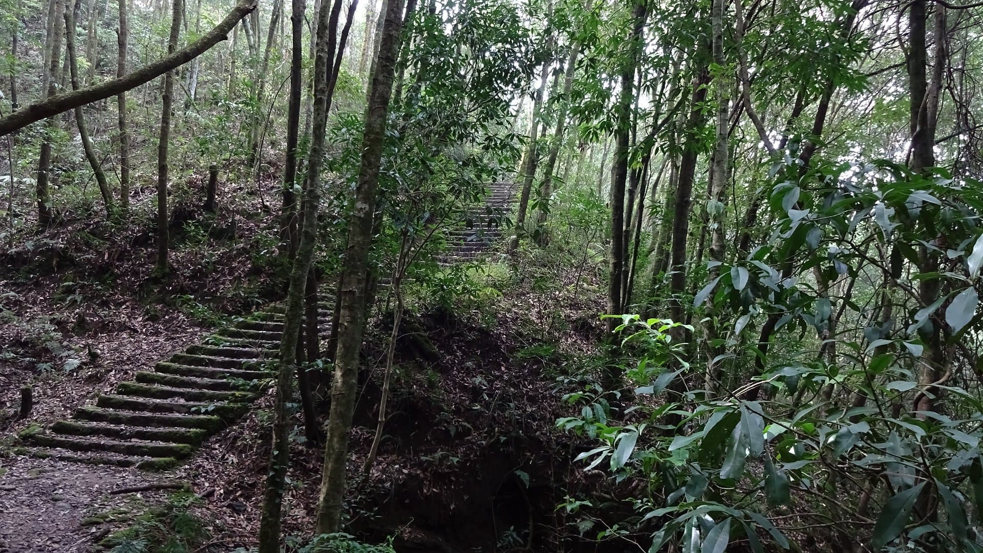
Into the Pine Forest

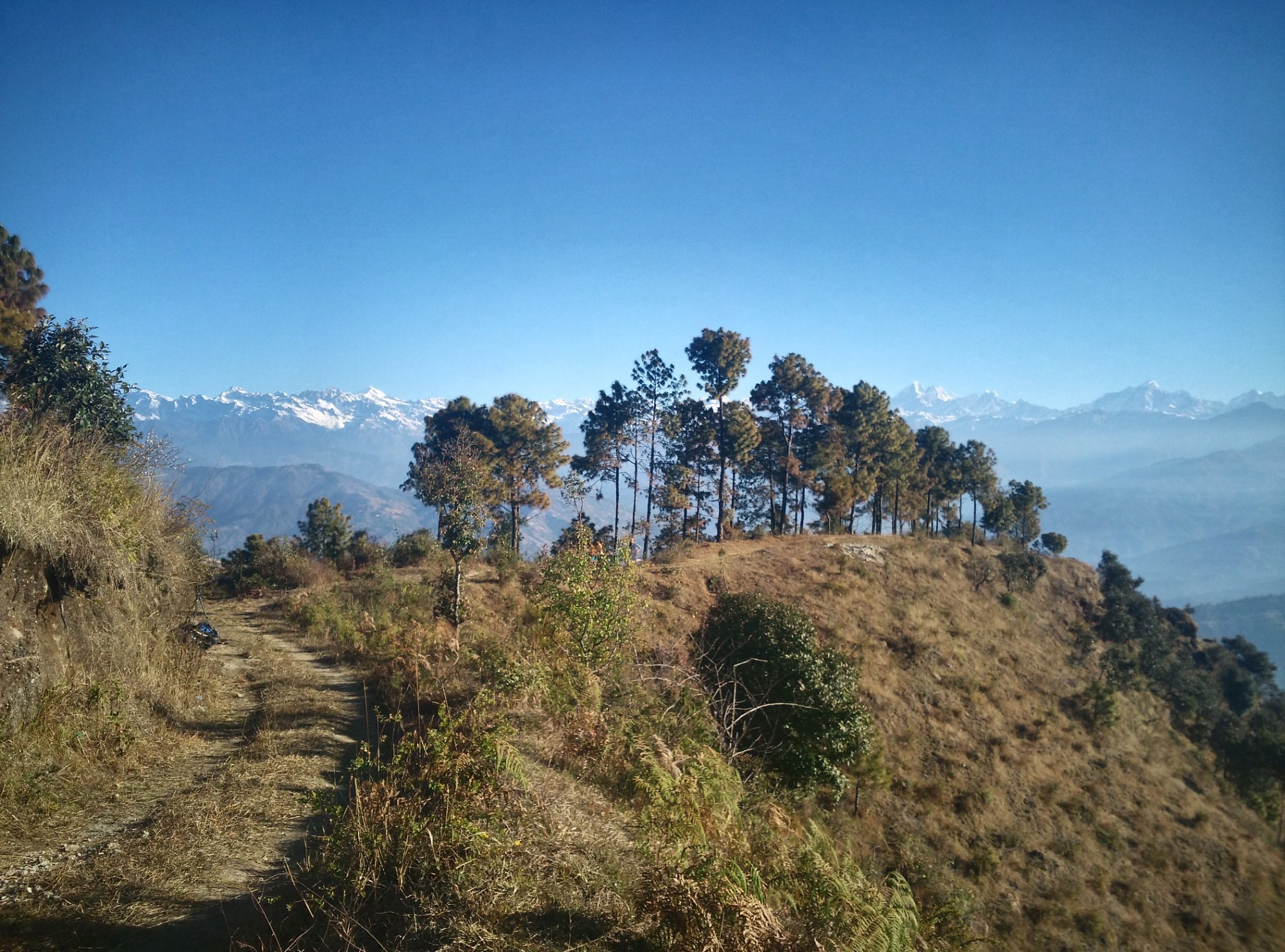
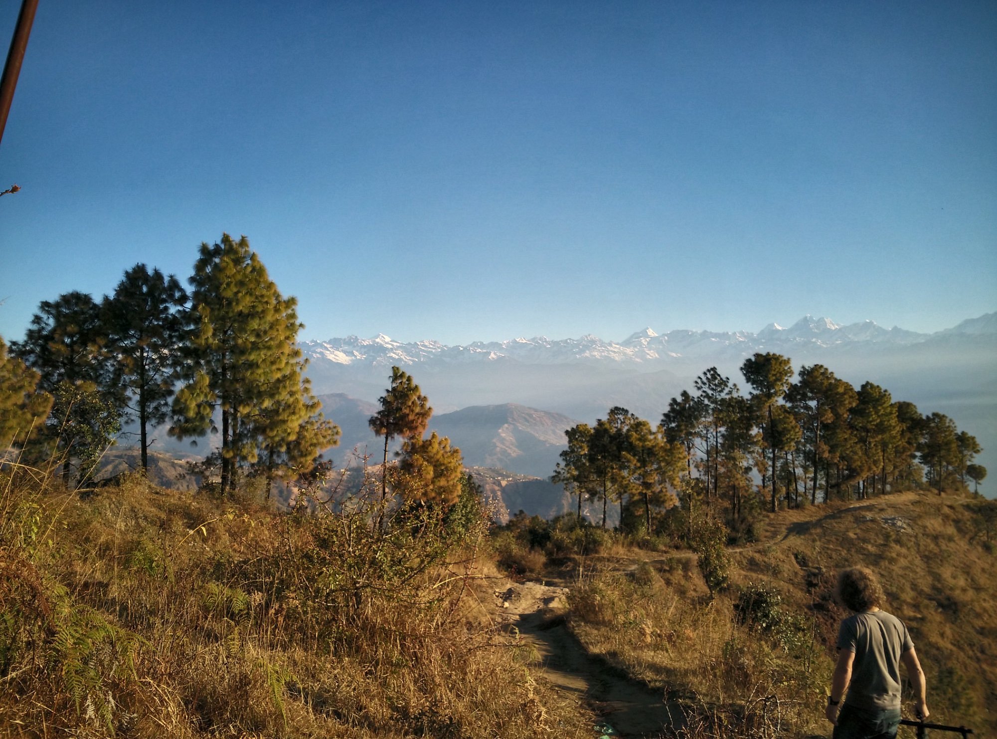
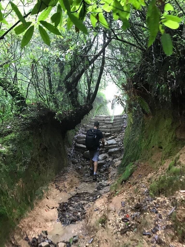
The loop begins near the Nagarkot View Tower or Bus Station area. Within the first few minutes, the road gives way to a narrow trail entering a thick forest of tall Himalayan pine (Pinus roxburghii). The change is immediate — road noise drops away, the air cools noticeably, and the forest closes around you.

This first section follows the ridgeline with minimal elevation gain. The path stays mostly shaded, making it ideal early in the morning when the sun is still low. It is quiet enough that you will hear more than you see — whistling thrush, Himalayan bulbul, and laughing thrush are commonly heard along this section.

Important note

This pine-forest section has several confusing junctions. A local guide is highly suggested, and offline GPS navigation is strongly recommended.

Pine forest section on the Nagarkot Panoramic Hiking Trail
Pine forest

Highlights

  • Excellent birdwatching in the quiet early hours
  • Sali River crossing is a natural rest point
  • Expect junctions — stick to your track and don’t rush
STAGE 2Distance ~5 km1.5–2 hrsTerraces + villages

Tamang Villages & Terraced Fields (Village Walk)

Leaving the forest, the world opens dramatically. You arrive at Kartike village (also written as Kattike or Katike), where the character of the hike transforms completely.

The path winds through working agricultural land. Depending on the season, terraces are planted with mustard (brilliant yellow in February), wheat, millet, or left fallow after the monsoon rice harvest.

Practical note

Several small tea shops operate along the village walk — budget NPR 200–400 for a simple meal and chiya.

Tamang village section on the Nagarkot Panoramic Hiking Trail
Village walk
Terraced fields along the Nagarkot village walk
Hiking path through the Nagarkot hills
STAGE 3Distance ~3 km45–60 minRidge panorama

The Panoramic Ridge & Return

From Dhanda Gaun village, look for a school with a blue-coloured roof — this is the key landmark. Turn right at the school, follow the path uphill for approximately five minutes, then turn left onto the elevated ridge path.

The ridge path follows an open, elevated ridgeline with the valley dropping away on both sides. On clear days, it acts like a natural observation deck with a sweeping Himalayan arc.

Photo tip

Best light is early morning (7–9 AM). Haze usually builds later, so start early for the clearest ridgeline views.

Panoramic ridge and return section on the Nagarkot Panoramic Hiking Trail
Ridge views

Key landmark

Blue-roof school in Dhanda Gaun is the most important junction for the ridge path.
Peaks visible on a clear day from Nagarkot Panoramic Trail
RangeNotable PeakAltitudeDistance
LangtangLangtang Lirung7,246 m~60 km
Ganesh HimalGanesh I7,422 m~75 km
JugalDorje Lakpa6,966 m~55 km
RolwalingGauri Shankar7,134 m~90 km
MahalangurMount EverestWorld's Highest8,849 m~145 km
ManasluManaslu8,163 m~175 km

Best visibility: early morning (6–9 AM), October–February. Haze typically builds after 10 AM. Everest (~145 km) is visible on exceptional clear days as a dark pyramid on the eastern horizon.

Blue-roof school

Key landmark in Dhanda Gaun — turn right here for the ridge path.

Mahankali Temple

Small stone shrine along the village walk, often decorated with marigold offerings.

Cheese factory

Local dairy producing traditional hill cheese; visible along the route and sometimes open to visitors.

Tips for This Trail

Small details that make your loop hike smoother and more memorable.

Views & photography

  • Clear mornings offer the best chance at Langtang, Ganesh Himal, Rolwaling, and distant Everest
  • The open ridge section acts like a natural viewing deck — pause before looping back
  • Bring a wide lens or phone panorama mode for the 180° ridgeline

What to bring

  • Sturdy walking shoes or trail runners
  • Reusable water bottle (at least 1.5 liters)
  • Hat, sunglasses, sunscreen, and a light jacket or windbreaker

Seasonal notes

  • Autumn (Sept–Nov) & spring (Mar–May): ideal clarity and comfortable temperatures
  • The trail is accessible year-round with the right gear
  • Monsoon: paths can be slick — take care on forest descents and river crossings

Guide, birds & fitness

  • Easy to moderate loop — suitable for most day hikers and families with a steady pace
  • Quiet pine sections are excellent for birdwatching — move slowly and listen
  • The pine-forest section has confusing junctions — a local guide is highly suggested (and offline GPS helps)
Pine forest on the Nagarkot Panoramic Hiking Trail
Trail views near Nagarkot
Shaded path through the forest
Terraced fields near Tamang villages on the loop
Nature & villages
Two experiences in one loop

Panoramic Trail & Tamang Village Walk

The panoramic route is really two hikes in one: the calm, shaded Nagarkot Nature Trail through tall pine, and the culturally rich Tamang Village Walk past stone houses, terraces, and daily farm life.

In the forest, bird calls and pine scent set the pace. Where the trail opens, mustard terraces and hamlets like Kartike reveal how hillside communities have lived here for generations — a gentle, authentic contrast to Kathmandu, only about 32 km away.

On clear days, the ridge delivers a sweeping Himalayan backdrop. The loop then brings you back toward central Nagarkot, so you finish near where you began — ideal for a self-contained day hike.

Pine forest & ridgeline walking
Tamang hamlets & terraces
Respectful village etiquette
Seasons

Monthly Weather & Best Time to Visit

Nagarkot Panoramic Trail conditions and Himalayan visibility vary significantly by season. Plan around October–February for the clearest mountain views.

MonthWeatherTrailHimalayan Views
JanBestCold (0–10°C), clearFirm, dry
Excellent
FebBestCool, mustard in bloomGood
Very good
MarMild, rhododendrons bloomingGood
Good
AprWarm, hazy afternoonsGood
Moderate (AM)
MayWarm, pre-monsoon hazeGood
Fair
JunMonsoon beginsSlippery in places
Moderate
JulHeavy rainMuddy, leeches
Moderate
AugHeavy rainMuddy, leeches
Moderate
SepMonsoon ends, lush greenImproving
Improving
OctBestCool, crystal-clear airIdeal
Outstanding
NovBestCool, very clearIdeal
Outstanding
DecBestCold morningsGood
Excellent
Monsoon note: June–August trails become muddy; leeches present in forest undergrowth. Wear full-coverage shoes and carry salt as a leech deterrent.

Planning Your Hike

What to expect on this loop — from independence to optional guiding and local fees.

Marked loop

Popular day loop — you finish near where you began in Nagarkot

Safe & accessible

Well-traveled route; suitable for independent hikers with preparation

Guide highly suggested

The pine-forest section has confusing junctions — a guide helps avoid wrong turns

No entry fee

No entry fee is required specifically for the Panoramic Hiking Trail loop

Getting Here

Getting to Nagarkot from Kathmandu

We maintain a dedicated, up-to-date transport guide with taxi prices, bus options, and practical tips for planning your trip to Nagarkot.

Taxi / private carLocal bus

Read the full transport guide

See route options, typical travel times, current price ranges, and practical tips for getting to Nagarkot from Kathmandu and Bhaktapur.

Nagarkot Panoramic Hiking Trail — common questions

Distance, difficulty, seasons, guides, fees, and Everest views — quick answers for planning your loop hike.

How long is the Nagarkot Panoramic Hiking Trail?

The Nagarkot Panoramic Hiking Trail is a 12-kilometer (7.5 miles) loop. At a comfortable walking pace with photo stops, it typically takes 3 to 4.5 hours to complete the full circuit.

How difficult is the Nagarkot Panoramic Day Hike?

The trail is rated Easy to Moderate. There are no steep technical sections, no altitude sickness risk, and no exposure. Total elevation gain and loss is modest — around 200–300 metres throughout the loop. It is suitable for most day hikers, families with older children (8+), and beginners with a reasonable base fitness level.

Can I see Mount Everest from the Nagarkot Panoramic Trail?

Yes — on very clear days, particularly in winter (October–February), Everest is visible from the ridge section. It appears as a dark pyramid approximately 145 km to the east. Visibility is best in the early morning before haze builds. It is not guaranteed on every visit — clear-sky days in autumn and winter give the best odds.

Do I need a guide for the Nagarkot Panoramic Hiking Trail?

No permit or guide is legally required. The trail is popular and generally well-travelled. However, a local guide is recommended for first-time visitors, solo hikers, and anyone who wants to get more from the village walk and peak identification on the ridge. The Dhanda Gaun junction can disorient first-timers without a map.

What is the best time of year to hike the Nagarkot Panoramic Trail?

October, November, and December offer the best combination of clear skies, cool temperatures, and outstanding Himalayan views. January and February are also excellent — February adds mustard fields in bloom. March and April are the next best choice, with wildflowers and rhododendrons. Avoid the monsoon months (June–August) unless you are comfortable with muddy trails and leeches.

Is there an entry fee for the Nagarkot hiking trail?

No — there is no entry fee specifically required to hike the Nagarkot Panoramic Hiking Trail loop.

Is the trail safe for solo hikers?

Yes. The Nagarkot Panoramic Hiking Trail is one of the safer short hikes in Nepal. The route passes through inhabited villages, is well-travelled during peak season, and presents no serious wilderness risk. Solo hikers — including solo women — regularly complete this loop without incident. Standard precautions apply: inform your hotel of your plans, carry a charged phone with an offline map, and start early.

Are there tea shops and food available on the trail?

Yes. Several small tea shops operate along the village walk section, particularly around Kartike village. Basic food (dal bhat, noodles, boiled eggs, biscuits) and drinks (chiya, bottled water, soft drinks) are available. Budget NPR 200–400 for a basic meal. The forest and ridge sections have no facilities — carry snacks from Nagarkot for those segments.

What birds can I see on the Nagarkot trail?

The pine forest section is excellent for birdwatching. Species regularly spotted include the whistling thrush, Himalayan bulbul, laughing thrush, great barbet, red-billed blue magpie, and various warblers and flycatchers. April and May add migratory species. Move slowly and quietly in the first forest section for the best sightings. Over 20 butterfly species have also been recorded along this belt.

Can I do the trail in reverse (clockwise)?

Yes — the loop can be walked in either direction. Counter-clockwise (forest first, villages second) is the more commonly recommended direction because it saves the panoramic ridge as a reward for the final section. Clockwise works equally well if you prefer to start with village walking while your legs are fresh.

Other featured trails

Short add-ons that fit before or after the Panoramic Hiking Trail.

Himalayan sunrise panorama from Nagarkot View Tower
Featured trail

Nagarkot View Tower & Village Walk

Sunrise at the View Tower, breakfast, then a guided village walk through Tamang settlements — a perfect add-on for short visits.

SunriseVillage walkEasy pace
Changu Narayan Temple courtyard and heritage architecture
Featured trail

Nagarkot to Changu Narayan Temple Trail

A scenic descent from Nagarkot toward Nepal’s oldest temple — forests, terraces, villages, and a heritage finish.

Heritage trailTemple finishDescent

Ready to Hike This Loop?

Contact us to arrange a local guide, transport, or a tailored Nagarkot day around the Panoramic Hiking Trail.

We share route pacing, weather timing, and photo-stop suggestions from current local trail experience, so you can hike with confidence even on your first Himalayan viewpoint trail.